
Some source maps, charts and plans retain Turkish labels; the captions are in English. Label key: harita = map; köy = village; merkez = town centre; yol = road; nehir = river; nüfus = population; göç = migration; yıl = year; kadın = female; erkek = male; eski = historical; güncel = present-day; compass K/D/G/B = N/E/S/W.
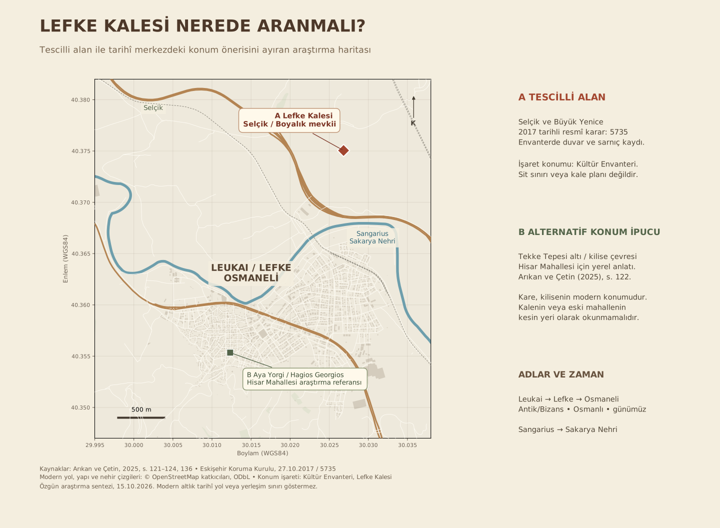
Why Are Two Locations Shown Separately?
A. Selçik / Boyalık Area
Eskişehir Regional Conservation Board decision no. 5735 of 27 October 2017 registers Lefke Castle, identified in Selçik and Büyük Yenice villages, as a first-degree archaeological site. The attached inventory form gives Selçik Village / Boyalı, with Boyalık in the description. It records a surrounding wall, building debris and a cistern about 8 × 9 m. Dating is uncertain; the form suggests an early Ottoman period. [2]
Arıkan and Çetin report Öztürk’s 2022 description: within Selçik boundaries, opposite the new bus terminal on the Ankara–Istanbul road. This and the official record’s Selçik reference should be assessed together; without matching plots and boundaries, they cannot be asserted to describe exactly the same area. [1, p. 122]
B. Below Tekke Hill / Church Area
The 2025 article reports former mayor Münir Şahin’s account placing Hisar neighbourhood below Tekke Hill and around the church. It also mentions a cistern lined with lime-and-crushed-brick mortar in the 2006 inventory. These are leads for the historic centre; they do not establish Hisar’s boundaries or a castle plan. [1, p. 122]
The square on the map marks Aya Yorgi Church, not coordinates for Tekke Hill, Hisar neighbourhood or Lefke Castle. Proximity does not mean the church and castle were the same building.
What Do Written Records Tell Us?
The article notes Ottoman chronicles linking Lefke to Osman Bey’s Sakarya campaign. Evliya Çelebi describes a small, square, ruined stone castle. The sixteenth-century name Hisar neighbourhood preserves a memory of a fortress; the authors report not finding it in nineteenth-century records. A documentary chain is still required to connect the neighbourhood name, traveller’s description and surviving remains. [1, pp. 121–122]
The article’s statement that the castle “has not survived” must be read alongside the official inventory of remains, clarifying which physical area and period are meant. This page does not collapse the two records into one definite conclusion. Figure 18 also says “probable area”; its photograph is not a georeferenced boundary plan. [1, p. 136; 2]
Historical and Modern Names
| Historical name / use | Modern equivalent | Reading note |
|---|---|---|
| Leukai | Osmaneli settlement | Ancient and Byzantine place name, not a specific name for the castle building. [3] |
| Lefke | Osmaneli | The article reports approval of the name change on 8 April 1914. [1, p. 122, n. 25] |
| Sangarius | Sakarya River | Historical river name reported by the article. The mapped river line uses a modern base. [1, p. 121, n. 21] |
| Gallus / Lefke Suyu / Yenişehir Suyu | Göksu | Historical and local names discussed in relation to the Göksu towers, beyond this town-centre map. [1, p. 123, n. 27] |
| Hisar Neighbourhood | No verified boundary correspondence | Below Tekke Hill and around the church is a local account reported by the article. [1, p. 122] |
| Hagios Georgios / Aya Yorgi | Aya Yorgi Church | Reference building on the modern map, not identical with the castle. [3, 4] |
Do Not Conflate Watchtowers with Lefke Castle
The article treats Cambazkaya as a separate watchpoint within Kızılöz. The Göksu / Düzmeşe towers in Çiftlik village are associated with the small stronghold granted to Samsa Çavuş in the chronicles. “Çavuş Castle” is a proposed name based on that association. Neither structure should be presented as an alternative name for the castle in the town centre. Göksu discussion. [1, pp. 122–124]
Map Method and Limitations
Road, river, railway and building lines come from OpenStreetMap. Marker A uses the approximate reference 40.37505 N, 30.02683 E published by Kültür Envanteri; it does not digitise the official site boundary or represent an official survey point. B is the mapped church footprint’s centre. Because the stamp on the coordinate-bearing plan in the 2017 file also shows a different decision number, no unverified boundary polygon was derived from it.
Historical names on the map belong to different periods, not one contemporary town plan. Confirmation requires comparison of approved board plans, cadastral and old neighbourhood records, with archaeological investigation to date the remains.
Sources and Verification
- Arıkan, Refik and Mehmet Can Çetin (2025). “Osman Gazinin 1304 Sakarya Seferi: Leblebici, Çadırlı ve Lefke Kalelerinin Tespiti Üzerine Bir Çalışma” [Osman Gazi’s Sakarya Campaign of 1304: Identifying Leblebici, Çadırlı and Lefke Castles]. Sinop University Journal of Social Sciences 9(1), 109–147, especially pp. 121–124 and 136. DOI. The article’s photographs were not copied into this map.
- Eskişehir Regional Conservation Board, 27 October 2017, decision 5735; attached registration form and plans. Unmodified official file · Ministry source.
- Seçkin Evcim (2010), “Bilecik-Osmaneli’de Bir Osmanlı Dönemi Rum Kilisesi: Hagios Georgios” [An Ottoman-period Greek Orthodox Church in Bilecik-Osmaneli: Hagios Georgios]. Research text. For the names Leukai and Hagios Georgios.
- OpenStreetMap, Aya Yorgi building; © OpenStreetMap contributors, ODbL. Base data: 15 October 2026. OSM data used in the map.
- Kültür Envanteri, Lefke Castle. Source of the approximate location marker, not a substitute for official boundary documentation.
Back to Maps · Context of the 1304 campaign · General bibliography
Contribute to the Research
If you have photographs, documents, gravestone records or family accounts relating to Lefke, please share them with us.
✉ Contact Form